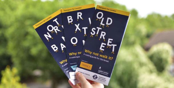
Brixton is one of three areas covered in new limited edition maps issued by Transport for London (TfL) to mark the tenth anniversary of its Legible London signage.
The fold-out maps are in the same style as the 1,700 Legible London signs around the city and have been produced by TfL in partnership with illustrator Matt Blease and business improvement districts (BIDs) in Brixton, Old Street and the “North Bank” area centred around Covent Garden.
TfL say the new Brixton map should be available at the Tube station today (19 September).
They are designed to help people living, working in and visiting London to walk regularly around the capital.
Public Health England recently released research showing that millions of people in the UK do not walk the recommended amount each month.
Michael Smith, chief executive of Brixton BID, said: “This new map will point the way and encourage more people to walk to Brixton destinations, knowing how long their walk will take.
“Brixton BID is happy to partner with TfL and its citywide wayfinding system, encouraging walking in Brixton and all over London.”
TfL says it is still working with boroughs, businesses and other partners to install new signs.
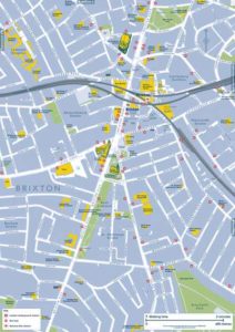
TfL was one of the organisations that the Sleepless Brixton campaign called on to help stop late night and early morning noise in Brixton by directing visitors walking to the station for the Night Tube away from residential areas like Electric Avenue – which features in the new map.
TfL has offered to meet the campaigners to discuss the problem.
According to the Greater London Authority, if every Londoner walked or cycled for 20 minutes a day, it would save the NHS £1.7bn in treatment costs over the next 25 years.
London mayor Sadiq Khan’s draft transport strategy envisages increasing the proportion of people walking, cycling and taking public transport to 80% of journeys by 2041, compared to 64% now. This would mean an average of 3 million fewer car journeys in London each day.
The new maps include a scale to work out distances that can be walked in five minutes.
Matt Blease said: “I’ve been really concerned about air quality in London for a while. When I found out about the project I jumped at the opportunity to get involved. Walking is the ultimate way to explore London and helps us all breathe a little easier.”
TfL launched new versions of its Walking Tube map earlier this year. They cover zones 1 to 3 and include National Rail stations. The maps show distances between stations and times on the same line.
Public Health England’s new One You physical activity campaign encourages adults to build 10 minutes continuous brisk walking into their day as a simple way to improve their health. A free Active 10 app has been developed to show how much brisk walking a person is doing each day and how to do more.


Nice to see all those public toilets carefully shown on the map!